
|
 These
county and county - equivalent data are based on tests of tissue samples from
dead and diseased wild birds, provided by state health officials. Many of these
data represent crows, which are especially sensitive to West Nile Virus (WNV).
Note that the map includes all areas of positive (confirmed or probable) WNV
results, but not necessarily all areas with submitted samples or no reports.
These
county and county - equivalent data are based on tests of tissue samples from
dead and diseased wild birds, provided by state health officials. Many of these
data represent crows, which are especially sensitive to West Nile Virus (WNV).
Note that the map includes all areas of positive (confirmed or probable) WNV
results, but not necessarily all areas with submitted samples or no reports.
| Note: These data are provisional and may be revised or adjusted in the future |
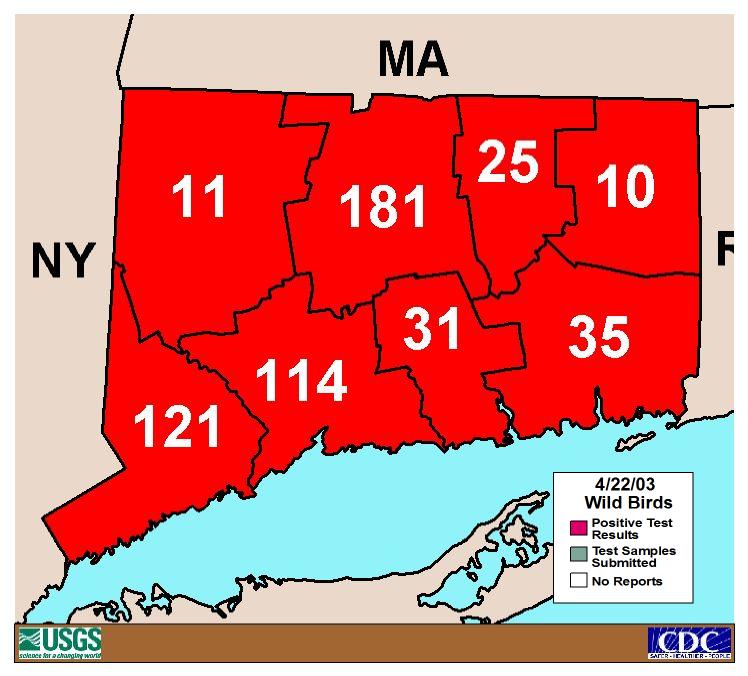
| Fairfield County | 121 |
| Hartford County | 181 |
| Litchfield County | 11 |
| Middlesex County | 31 |
| New Haven County | 114 |
| New London County | 35 |
| Tolland County | 25 |
| Windham County | 10 |
| Cumulative Report Maps for the year 2002, Connecticut | |||
| Cumulative Human | Cumulative Veterinary | Cumulative Mosquito | Cumulative Sentinel Flock |
Human
West Nile Virus Surveillance
State of Connecticut
Mosquito Management Program
West Nile Virus Fact
Sheet
For further information or questions, please contact the Centers for Disease
Control and Prevention:
email: dvbid@cdc.gov
(970) 221-6400